Water Information Management System

Resolving Groundwater and Water Quality uncertainty for Mining Operations


WIMS transforms fragmented borehole, water level, abstraction, flow and water quality monitoring data into one trusted source of truth—giving hydrogeologists and environmental teams the clarity they need to make confident operational and compliance decisions.WIMS is a real-time groundwater and water balance intelligence system purpose-built for mining operations, enabling hydrogeologists and environmental managers to resolve uncertainty and make confident operational and compliance decisions.


Stop chasing spreadsheets. Start understanding your groundwater system.

A Single Source of Truth for Water Monitoring

Mining operations generate large volumes of groundwater and water quality monitoring data from boreholes, telemetry systems, laboratory results and field inspections.  Too often this information is scattered across spreadsheets, disconnected systems and field notes. WIMS brings all of this data together into one structured platform—allowing hydrogeologists and environmental teams to focus on interpreting groundwater behaviour instead of chasing data.

WIMS PUTS YOU IN CONTROL

WIMS Puts YOU in control


With WIMS your data belongs to you! After your historic and new data is secured and validated, you remain in control of your data. Secure, accurate and accessible data with dynamic reporting capabilities - WIMS is a game changer and will exceed your water management expectations.


Ask yourself this: Do I currently trust the integrity of my data?

Understand Groundwater Behaviour Faster


WIMS combines groundwater levels, abstraction data, flow monitoring and water quality information in a single platform.

Interactive visualisations and spatial intelligence help hydrogeologists quickly identify patterns, anomalies and emerging risks across complex mining environments.  Instead of reconciling spreadsheets, teams can focus on interpreting the groundwater system.


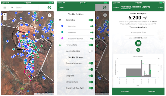
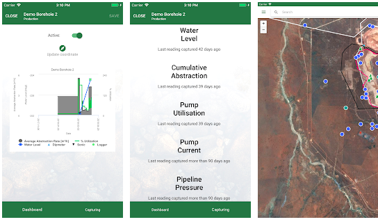
Built for Field Data Capture


Field technicians can capture borehole measurements, flow readings and environmental observations directly from the WIMS mobile app. This replaces paper notebooks and manual transcription, improving data accuracy and ensuring monitoring data is immediately available for analysis.


Designed for Real Mining Environments


WIMS supports complex hydrogeological monitoring programmes, including:

  • angled boreholes
  • large historical datasets
  • integration with telemetry systems
  • laboratory water quality data

Resolving Groundwater and Water Quality Uncertainty

Water decisions on a mine site carry real operational and environmental risk.  Hydrogeologists must understand:

  • whether the pit will remain dry
  • whether groundwater abstraction is sustainable
  • whether sufficient water is available for the plant
  • whether water quality remains within licence limits


When monitoring data is fragmented, these questions become difficult to answer with confidence.  WIMS consolidates groundwater and water quality monitoring into a single trusted dataset, allowing teams to detect risks earlier and make informed decisions.

In hydrological and hydrogeological consulting, large data sets are gathered across multiple projects and clients. This data consists of numerous different types of complex data sets that have temporal and spatial relations. WIMS has proven itself as a powerful unique solution able to take the load off your shoulders. 


Seamless integration with Excel makes WIMS’ import and export capabilities second to none on a secure platform. This not only guarantees long-term data integrity, but also data intelligence, quality assurance and control over your data.


Hydrogeological professionals sell knowledge, which are captured and transmitted via technical reports. Automation and optimisation of this process not only saves money and valuable resources, but in terms of insight and proactive decision-making, it also makes your data worth more than gold. 

Mines, municipalities etc. are required by environmental legislation to monitor surface water and groundwater quantity (flows), water levels and water quality parameters. This data usually ends up in spreadsheets or informal database systems. Masses of data is generated annually by mining houses and other institutions on site, and surrounding environs water quantity and quality. 

The quality of the water resource data consultants have to analyse and process is directly linked and usually limited by the availability and quality of the data. WIMS has built-in data quality checks.


Consultants, that have to analyse this data, are paid far more to retrieve the data every time there is a project than it costs your business to sign up for a WIMS license. At $20/month for the groundwater module WIMSHydro (boreholes, water levels, water quality, spatial data) and $9000/year for the full WIMS, which can store and report on the complete mine water balance flows and water quality data, the numbers speak for themselves. The cost of one inorganic chemical analysis is in the order of $120. A full WIMS license is equal to the cost of only 75 chemical analyses. This is equal to the chemical analysis of one sampling run at a medium-sized mining operation.

WIMS also has the ability to produce analytical data tables, graphs and reports. The ability to produce multi-parameter transient trend graphs, on the same page as a spatially intelligent plots, makes interpretation faster and more efficient. 

Customisation and automation of data tables, graphs and spatial plots based on statistical data analysis add immense value in the workflow, saving time and valuable human resources. 


Functionality for powerful data analytics and reports exist, but can also be expanded to mine large data sets in order to gain deep insight and knowledge. For e.g. the Tshiping Project (www.tshiping.co.za) where more than 4600 boreholes are based in two quaternary catchments, across hundreds of farms and multiple mines.

WIMS can link to LAB and SCADA systems to make data available. With the ability to customise and autogenerate reports companies can unlock exceptional value-adds in terms of time and effort (i.e. money) savings.

The journey from Data to Information to Knowledge, is a journey on which management decisions are based. With regards to water management, this journey can be facilitated and housed in WIMSHydro as part of a system process that can be partially automated and effectively accelerated. The data is usually analysed in numerous spreadsheets and stored in various locations. The problem is that the data in these sheets are neither relational nor checked for quality. WIMS as a virtual data warehouse and interpretation system can be used to make large data sets instantly available from numerous projects. 


This is extremely useful for mining clients as their data is usually based at consultants, so they repeatedly end up paying for data retrieval and analysis. 


From the consultant’s perspective it is time saving and valuable to relate all data from past and new projects. As qualified professionals typically only stay an average of 3-5 years at a company, WIMS serves as an institutional memory. WIMS saves time and money not only on historical data and projects, but also in relation between comprehensive and diverse projects.

There is currently no known integrated and dynamic mine water focused water data system that can compete with WIMS as it has the ability to accommodate and report on water data sites across numerous water use types (i.e. boreholes/wells, springs, rivers, dams, mine sections etc) that relates temporal and spatial data in custom graphs and maps.

Your Water Monitoring Data Is a Strategic Asset


Mining operations invest heavily in groundwater monitoring and water quality analysis. A typical mine can spend tens of thousands of dollars each year on chemical analyses alone, yet much of this valuable data ends up scattered across spreadsheets, disconnected databases or archived reports.  When monitoring data is difficult to retrieve or validate, its long-term value is lost.


WIMS preserves this investment by storing groundwater and water quality data in a structured, auditable and referenceable system, turning monitoring records into a reliable foundation for analysis, reporting and operational decision-making. 


Investing a small fraction of the monitoring budget in a system like WIMS transforms water data from a collection expense into a long-term operational asset.

Private & Confidential Data

Your data is securely stored and is accessible online at all times. As an accountability partner, WIMS would like you to know that your data is confidential, secure and cannot be lost.

WIMS QA & QC

WIMS is a data-intelligent system and features QAQC abilities to minimise data input errors e.g.

  1. Data can be imported directly from Lab LIMS systems
  2. Build-in QAQC checks, so that e.g. a pH of >14 cannot be read in etc.

WIMS Data Importing & Transferring Capabilities

Masses of data is accessible and can be imported from or exported to Excel, either in a step-by-step process or from a WIMS template. This is important from a consultant’s viewpoint, because you do not want your data locked in a system until it is completely understood.


WIMS also allows the flexibility to further analyse data and interpret data by working in Excel.

Water does not respect property boundaries. WIMS can accommodate catchment and sub-catchment spatial zoning. The benefits associated with water conservation and demand management that can be done based on the WIMS data is invaluable from a direct cost, social and environmental capital perspective.

In addition to the data stored for environmental reporting purposes, the WIMS data system can also store and integrate water quality data for health & safety and risk management purposes.

WIMS is excellent as a data warehouse, meaning it is suitable for multiple water users or impactors (which is often the case) to use simultaneously. Surface and groundwater do not respect property boundaries and therefore water resources have to be managed in an integrated way. Tshiping Water Users Association, where groundwater data is accommodated in more than 4600 boreholes, across hundreds of farms and tens of mines over two quaternary catchments, spanning rainfall and water level data from 1950, is a good example of the complex abilities of WIMS. 


Simply put, WIMS is the only way to manage water as a regional critical social resource.

Knowledge about water resources can not only save on capital but can also save lives. In developing countries where water is not only scarce but can be easily contaminated (around 45 000 children die each month in the DRC because of water borne diseases e.g. cholera).

Read the Case Studies

WIMS HydroGeology Modules

WATER QUALITY

Easily manage the three elements that make up water quality with just one app. It’s that convenient with WIMS.
More Info

BOREHOLES

Don’t let your highly valuable borehole data get lost in spreadsheets and management systems. 
More Info

WATER LEVELS

Capture and visualise aquifer water levels with WIMS. It’s not just easy and secure... it’s smart too.
More Info

CLIMATE DATA

Directly capture climate data or seamlessly integrate with existing data acquisition systems.  It's that easy.
More Info

ABSTRACTIONS AND FLOWS

Keep track of water abstractions and consumption by capturing flow
readings directly in WIMS.
More Info

LOCATION MANAGEMENT

Effortlessly set up, define or view locations with WIMS’ powerful
location management module.
More Info

ELECTRONIC INTEGRATIONS

WIMS’ tech-friendly system means seamless integration with your existing data acquisitions.
More Info

MOBILE APP

Download and try the WIMS app for free and you’ll see that data acquisition in the field has never been easier.
More Info

Download the WIMS Mobile App

Registration is FREE, no credit card required!

Step 1:  
Download the WIMS mobile app by clicking on the links below.

Step 2:  
Click on "Register for a free account" and complete the form.

You are now a registered WIMS user.  Capture data and log into the WIMS desktop app (app.wims.co.za) for the desktop version and detailed reports.
DOWNLOAD APP DOWNLOAD APP